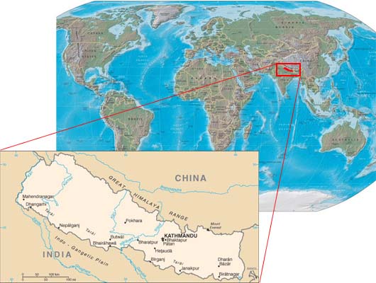
Geography of Nepal
Country Name: Nepal
Capital:
Kathmandu
Location:
Southern Asia, between China and India
Geographic coordinates: 28 00 N, 84 00 E
Map references:
Asia
Area: Total:
147,181 sq km
Lland: 143,181 sq km
water: 4,000 sq km
Area - comparative: slightly larger than Arkansas
Land boundaries:
total: 2,926 km
border countries:
China 1,236 km, India 1,690 km
Coastline:
0 km (landlocked)
Maritime claims: none (landlocked)
Climate:
varies from cool summers and severe winters in north
to subtropical summers and mild winters in south
Terrain:
Tarai or flat river plain of the Ganges in south, central
hill region, rugged Himalayas in north
Elevation extremes: lowest point: Kanchan Kalan 70 m highest
point: Mount
Everest 8,848 m
Natural resources: quartz, water, timber, hydropower,
scenic beauty,
small deposits of lignite, copper, cobalt, iron ore
Land use:
arable land: 16.07%
permanent crops: 0.85%
other:
83.08% (2005)
Natural hazards: severe thunderstorms,
flooding, landslides, drought,
and famine depending on the timing, intensity, and
duration of the summer monsoons
Environment-international agreements:
party to: Biodiversity, Climate Change, Climate Change-
Kyoto Protocol, Desertification, Endangered Species,
Hazardous Wastes, Law of the Sea,Ozone Layer
Protection, Tropical Timber 83, Tropical Timber
94,Wetlandssigned, but not ratified:Marine Life Conservation
Geography - note: landlocked;
strategic location between China and India;
contains eight of world's 10 highest peaks, including
Mount Everest and Kanchenjunga - the world'stallest and
third
tallest - on the borders with China and India respective
Population:
28,901,790 (July 2007 est.)
Country name: conventional long and short form: Nepal
local long and short form: Nepal
geographic coordinates: 27 43 N, 85 19 E
time difference: UTC+5.75 (10.75 hours ahead of Washington, DC during
Standard Time)
Administrative divisions:
14 zones (anchal, singular and plural); Bagmati, Bheri,
Dhawalagiri,Gandaki, Janakpur, Karnali, Kosi, Lumbini,
Mahakali,
Mechi, Narayani,
Rapti,Sagarmatha, Seti
Independence: 1768
(unified by Prithvi Narayan SHAH)