Around Annapurna circuit trek ( 21 Days )
Annapurna region is best described as the most happening
incentive trekking destination of Nepal.
The Annapurna Circuit Trek has been proved as a highly praised and spectacular trekking route in the Annapurna
region since it opened to foreign trekkers in 1977. This three weeks trek starts right from Beshishahar and goes along the
Marshyangdi River,
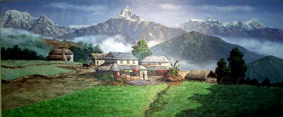
with great view of Manasalu and Himal Chuli to the east. This magnificent trek leads you to the fine village inhabited by
a wide diversity of people from different ethnic groups, offering spectacular and majestic view of the white Himalayas.
As it continues to the north of the main Himalayan range on to the high and dry Tibetan Plateau, the scenery is equally breathtaking.
The highest point of the trek is Thorung-la pass at the top of the valley at 5416m high. Due to the difficulties of crossing
the pass, the circuit is usually walked in a counter clockwise direction. Traveling clockwise the longer ascent and shorter
descent from west to east is too much for many peoples to manage in one day.
As we descend to the west at Muktinath from Manang, we continue to the barren Tibetan like village of the kali Gandaki - the
world's deepest gorge passes between the giant Annapurna and Dhaulagiri mountains. After
you cross the Thorung La, pass from Manang to Muktinath the final seven days of the circuit trek are the same as the Jomsom
Trek from Pokhara, but in reverse
Main highlights
Manang village, Thorung La Pass (5416m); The Pilgrimage town of Muktinath; Views of the Dhaulagiri Ice - Fall;
The worlds deepest gorge in the Kali Gandaki river; Hot Spring at Tatopani; and Sunrise and mountains views from Poon Hill
Itinerary:
Day 01
Your arrival to Tribhuwan International
Airport (TIA), you will be met by our Airport Representative, and transfer
to hotel. Overnight at hotel
Day 02
Drive Kathmandu
to Besishahar (790m).
About
5 hours scenic drive by car / van. Overnight at Guest House.
Day 03
Besishahar to Bahundanda (1310m).
Today our journey starts at Besishahar, from where, the trail makes the climb
to Khudi at 790m, we then reach the
first Gurung village (many of Nepal’s
Gurkha Soldiers are Gurungs). As we continue the from Khudi the trail offers fine views of Himalchuli and Peak 29 (Ngadi Chuli).
It climbs to Bhulbhule at 825m; it then goes to Ngadi before reaching Lampata at 1135m and nearby Bahundanda at 1310m.Overnight at Guest House.
Day 04 Bahundanda to Chyamje (1400m). Today the trail drops steeply to Syange at 1070m from Bahundanda crossing the Marsyangdi River on
a suspension bridge. We then follow the river to the stone village
of Jagat before climbing through forest to Chyamje at 1400m.
Day 05 Chyamje to Bagarchhap
(2160m).
The
day begins with the rocky trail following the Marsyandi Rivers steadily uphill to Tal at 1675m, the first village in the Manang
district. We make a trailverse crossing a wide, flat valley. The trail then climbs a stone stairway to 1860m till another
stairway. The journey continues making up and down to Dharapani at 1890m. There we find a stone entrance chorten typical of
the Tibetan influenced villages from here northwards. We then visit the Bagarchhap at 2160m that offers the typical flat roofed
stone houses of local Tibetans design although the village which is still in the transition Zone before the dry highlands.
Day 06 Bagarchhap to
Chame (2630m).
With often rough and rocky, the trail climbs to Tyanja at 2360m, & then continues through forest, but near the river, to Kopar at 2590m.
As we reach the Chame, the headquarters of the Manang district, we are rewarded by the fine views of Annapurna II as you approach
Chame & two small hot springs by the town.
Day 07 Chame to Pisang
(3300m).
The
day starts through deep forest in a steep and narrow valley, crosses a river on a long bridge at 2910m. We then cross another
bridge at 3040m, from there the view of the soaring Paungda Danda rock face really begins to appear. From there the trail
joins to climb to Pisang, which sprawls between 3200m & 3300m.
Day 08 Pisang to Manang
(3500m).
Today we continue through the drier
upper part of the Manang district, cut off from the full effect of the monsoon by the Anapurna Range. People of this region, herd
yaks & raise crops for part of the year besides, they also continue to enjoy special trading rights gained way back in
1784.Leaving Pisang, we have an alternate trails north and south of the Marsyangdi River which meet up again at Mungji. The
southern route by Hongde, with its airstrip, at 3325m involves less climbing than the northern route via Ghyaru, though there
are better views on the trail that follows the northern bank of the river. From Mungji, the trail continues past the picturesque
but partially hidden village of Bryanga
at 3475m to nearby Manang at 3500m.
Day 09 Manang - Acclimatization
day
Today
we spend a day acclimatizing in Manang. The whole day we spend by doing some fine day walks and overviewing the magnificent
views around the village & the day time is best to gain altitude. At the end of the day, we return back to our accommodation
& have a night rest.
Day 10 Manang to Ledar (4250m).
Today we leave Manang, & the trai makes an ascent of nearly 2000m to the
Thorung La pass. We make the climb steadily through Tenki, leaving the Marsyangi
Valley. Continuing along the Jarsang
Khola Valley, we reach Ledar
at 4250m, there we see the vegetations steadily more sparse.
Day 11 Ledar to Throng Phedi or High camp (4600m).
The trail descends
to cross the river at 4310m we then climb up to Phedi at 4420m. At High Camp on the elevation of 4600m, we can recently found
some good Guesthouses built. Your overnight stay will be there.
Day 12 Phedi or High Camp to Muktinath (3710m).
The journey from Phedi “foot of the hill” or at the foot to the 5416m
Thorung La pass, begins the day. We then make the climb steeply that is regularly used and easy to follow. However, the problem
may arise due to the altitude and snow. It often causes terrible problem to cross the pass if it is covered by snow. About
four hours climb up to the pass marked by the chortens & prayer flags. As you reach the top, you are rewarded by the magnificent
view from the top.
Day 13 Trek to Marpha (2667m)
This place is also nice settlements
of more than 100 houses of Thakali people. It has also 2 monasteries, and one apple brandy factory. If you are interested
to see how apple brandy are produced, you will be taken there.
Day 14 Trek to Ghasa (2100m)..
Day 15 Trek to Tatopani (1200m)
This place is famous for its hot spring. This is the best place to relax your body after a long days trek
Day 16 Rest day at Tatopani (hot spring).
Day 17 Trek to Ghorepani.
Day 18 Hiking to Poonhill - back to Ghorepani, and trek to Tadapani.
This morning, we will get up early in the morning,
and go for hiking to Poon Hill. From here you will see superb view of sunrise, and panoramic view of Himalayas, including
Mt. Dhaulagiri,
Annapurna South, Fishtail, and so on. After visiting Poonhill, we will come back to Ghorepani, have a hot breakfast, and continue
walking to Tadapani.
Day 19 Trek to Ghandruk
(2000m.).
Day
20 Trek to Pothana (1950m.).
Day 21 Trek down to Phedi,
and half an hour car drive to Pokhara.